Course Features
Price
Study Method
Online | Self-paced
Course Format
Reading Material - PDF, article
Duration
6 hours, 15 minutes
Qualification
No formal qualification
Certificate
At completion
Additional info
Coming soon
- Share
Overview
The Photogrammetry and Remote Sensing Level 3 Advanced Diploma is an in-depth training programme designed to equip students with essential knowledge and hands-on skills in geospatial data collection and analysis. This course introduces learners to the foundational principles and technologies that power modern photogrammetry and remote sensing, focusing on their practical applications across a variety of industries.
Beginning with a detailed introduction to the field, students explore the evolution of photogrammetry and remote sensing, gaining insight into how these disciplines have become critical tools in environmental science, urban development, agriculture, disaster management, and more. The curriculum covers camera calibration, stereoscopic vision, image acquisition, and the geometric principles behind 3D imaging, setting the stage for more advanced applications.
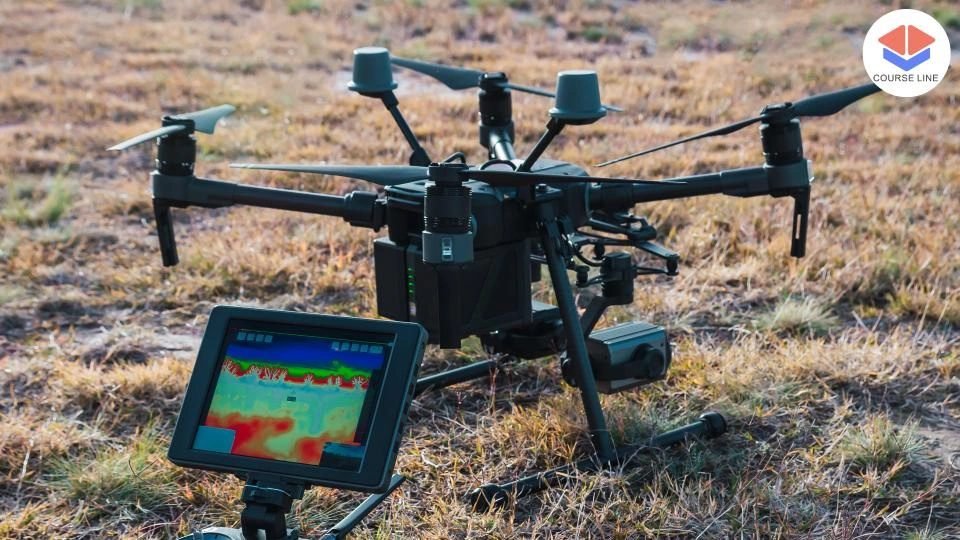
The course delves into various data acquisition techniques, including aerial photography, satellite imaging, and the use of Unmanned Aerial Vehicles (UAVs). Learners explore how to process and correct imagery through geometric and radiometric methods, followed by orthorectification and digital elevation model (DEM) generation for accurate spatial representation.
Digital image processing is a core component of the diploma, introducing preprocessing techniques such as filtering and enhancement, as well as image classification, feature extraction, and change detection analysis. These skills are critical for interpreting complex datasets and delivering actionable insights. Students also learn 3D reconstruction techniques, including Structure from Motion (SfM), point cloud generation, and surface modeling, which are increasingly used in engineering, architecture, and simulation technologies.
Advanced modules focus on cutting-edge remote sensing techniques, including hyperspectral imaging, LiDAR data processing, and thermal analysis. Learners also examine the integration of multi-sensor datasets to improve accuracy and expand analytical capabilities. The course concludes with real-world applications across key industries such as urban planning, environmental monitoring, agriculture, forestry, and disaster management.
Students will also complete a guided project, applying the skills and concepts they've learned to a real-world problem. This project-based approach reinforces learning through practice and fosters the confidence needed for professional roles. The final lecture explores emerging trends and the future of the industry, highlighting innovative technologies and potential areas for research and career growth.
By the end of the course, learners will have developed a strong foundation in photogrammetry and remote sensing, along with the ability to apply these tools to solve real-world spatial challenges and contribute to high-impact sectors globally.
This course is ideal for aspiring geospatial analysts, environmental scientists, urban planners, surveyors, remote sensing specialists, or students in related disciplines who wish to gain practical expertise in photogrammetry and spatial data analysis.
A basic understanding of geography, mathematics, or computer science is recommended. Familiarity with GIS concepts or prior experience in geospatial technologies will be beneficial but is not mandatory. Access to a computer and internet connection is required to complete hands-on assignments and projects.
Graduates of the Photogrammetry and Remote Sensing Level 3 Advanced Diploma can pursue careers as remote sensing analysts, GIS technicians, photogrammetrists, spatial data specialists, environmental consultants, or urban planning professionals. The course also provides a strong foundation for further study in geospatial science, civil engineering, or environmental technology.
Who is this course for?
The Photogrammetry and Remote Sensing Level 3 Advanced Diploma is an in-depth training programme designed to equip students with essential knowledge and hands-on skills in geospatial data collection and analysis. This course introduces learners to the foundational principles and technologies that power modern photogrammetry and remote sensing, focusing on their practical applications across a variety of industries.
Beginning with a detailed introduction to the field, students explore the evolution of photogrammetry and remote sensing, gaining insight into how these disciplines have become critical tools in environmental science, urban development, agriculture, disaster management, and more. The curriculum covers camera calibration, stereoscopic vision, image acquisition, and the geometric principles behind 3D imaging, setting the stage for more advanced applications.
The course delves into various data acquisition techniques, including aerial photography, satellite imaging, and the use of Unmanned Aerial Vehicles (UAVs). Learners explore how to process and correct imagery through geometric and radiometric methods, followed by orthorectification and digital elevation model (DEM) generation for accurate spatial representation.
Digital image processing is a core component of the diploma, introducing preprocessing techniques such as filtering and enhancement, as well as image classification, feature extraction, and change detection analysis. These skills are critical for interpreting complex datasets and delivering actionable insights. Students also learn 3D reconstruction techniques, including Structure from Motion (SfM), point cloud generation, and surface modeling, which are increasingly used in engineering, architecture, and simulation technologies.
Advanced modules focus on cutting-edge remote sensing techniques, including hyperspectral imaging, LiDAR data processing, and thermal analysis. Learners also examine the integration of multi-sensor datasets to improve accuracy and expand analytical capabilities. The course concludes with real-world applications across key industries such as urban planning, environmental monitoring, agriculture, forestry, and disaster management.
Students will also complete a guided project, applying the skills and concepts they've learned to a real-world problem. This project-based approach reinforces learning through practice and fosters the confidence needed for professional roles. The final lecture explores emerging trends and the future of the industry, highlighting innovative technologies and potential areas for research and career growth.
By the end of the course, learners will have developed a strong foundation in photogrammetry and remote sensing, along with the ability to apply these tools to solve real-world spatial challenges and contribute to high-impact sectors globally.
This course is ideal for aspiring geospatial analysts, environmental scientists, urban planners, surveyors, remote sensing specialists, or students in related disciplines who wish to gain practical expertise in photogrammetry and spatial data analysis.
A basic understanding of geography, mathematics, or computer science is recommended. Familiarity with GIS concepts or prior experience in geospatial technologies will be beneficial but is not mandatory. Access to a computer and internet connection is required to complete hands-on assignments and projects.
Graduates of the Photogrammetry and Remote Sensing Level 3 Advanced Diploma can pursue careers as remote sensing analysts, GIS technicians, photogrammetrists, spatial data specialists, environmental consultants, or urban planning professionals. The course also provides a strong foundation for further study in geospatial science, civil engineering, or environmental technology.
Requirements
The Photogrammetry and Remote Sensing Level 3 Advanced Diploma is an in-depth training programme designed to equip students with essential knowledge and hands-on skills in geospatial data collection and analysis. This course introduces learners to the foundational principles and technologies that power modern photogrammetry and remote sensing, focusing on their practical applications across a variety of industries.
Beginning with a detailed introduction to the field, students explore the evolution of photogrammetry and remote sensing, gaining insight into how these disciplines have become critical tools in environmental science, urban development, agriculture, disaster management, and more. The curriculum covers camera calibration, stereoscopic vision, image acquisition, and the geometric principles behind 3D imaging, setting the stage for more advanced applications.
The course delves into various data acquisition techniques, including aerial photography, satellite imaging, and the use of Unmanned Aerial Vehicles (UAVs). Learners explore how to process and correct imagery through geometric and radiometric methods, followed by orthorectification and digital elevation model (DEM) generation for accurate spatial representation.
Digital image processing is a core component of the diploma, introducing preprocessing techniques such as filtering and enhancement, as well as image classification, feature extraction, and change detection analysis. These skills are critical for interpreting complex datasets and delivering actionable insights. Students also learn 3D reconstruction techniques, including Structure from Motion (SfM), point cloud generation, and surface modeling, which are increasingly used in engineering, architecture, and simulation technologies.
Advanced modules focus on cutting-edge remote sensing techniques, including hyperspectral imaging, LiDAR data processing, and thermal analysis. Learners also examine the integration of multi-sensor datasets to improve accuracy and expand analytical capabilities. The course concludes with real-world applications across key industries such as urban planning, environmental monitoring, agriculture, forestry, and disaster management.
Students will also complete a guided project, applying the skills and concepts they've learned to a real-world problem. This project-based approach reinforces learning through practice and fosters the confidence needed for professional roles. The final lecture explores emerging trends and the future of the industry, highlighting innovative technologies and potential areas for research and career growth.
By the end of the course, learners will have developed a strong foundation in photogrammetry and remote sensing, along with the ability to apply these tools to solve real-world spatial challenges and contribute to high-impact sectors globally.
This course is ideal for aspiring geospatial analysts, environmental scientists, urban planners, surveyors, remote sensing specialists, or students in related disciplines who wish to gain practical expertise in photogrammetry and spatial data analysis.
A basic understanding of geography, mathematics, or computer science is recommended. Familiarity with GIS concepts or prior experience in geospatial technologies will be beneficial but is not mandatory. Access to a computer and internet connection is required to complete hands-on assignments and projects.
Graduates of the Photogrammetry and Remote Sensing Level 3 Advanced Diploma can pursue careers as remote sensing analysts, GIS technicians, photogrammetrists, spatial data specialists, environmental consultants, or urban planning professionals. The course also provides a strong foundation for further study in geospatial science, civil engineering, or environmental technology.
Career path
The Photogrammetry and Remote Sensing Level 3 Advanced Diploma is an in-depth training programme designed to equip students with essential knowledge and hands-on skills in geospatial data collection and analysis. This course introduces learners to the foundational principles and technologies that power modern photogrammetry and remote sensing, focusing on their practical applications across a variety of industries.
Beginning with a detailed introduction to the field, students explore the evolution of photogrammetry and remote sensing, gaining insight into how these disciplines have become critical tools in environmental science, urban development, agriculture, disaster management, and more. The curriculum covers camera calibration, stereoscopic vision, image acquisition, and the geometric principles behind 3D imaging, setting the stage for more advanced applications.
The course delves into various data acquisition techniques, including aerial photography, satellite imaging, and the use of Unmanned Aerial Vehicles (UAVs). Learners explore how to process and correct imagery through geometric and radiometric methods, followed by orthorectification and digital elevation model (DEM) generation for accurate spatial representation.
Digital image processing is a core component of the diploma, introducing preprocessing techniques such as filtering and enhancement, as well as image classification, feature extraction, and change detection analysis. These skills are critical for interpreting complex datasets and delivering actionable insights. Students also learn 3D reconstruction techniques, including Structure from Motion (SfM), point cloud generation, and surface modeling, which are increasingly used in engineering, architecture, and simulation technologies.
Advanced modules focus on cutting-edge remote sensing techniques, including hyperspectral imaging, LiDAR data processing, and thermal analysis. Learners also examine the integration of multi-sensor datasets to improve accuracy and expand analytical capabilities. The course concludes with real-world applications across key industries such as urban planning, environmental monitoring, agriculture, forestry, and disaster management.
Students will also complete a guided project, applying the skills and concepts they've learned to a real-world problem. This project-based approach reinforces learning through practice and fosters the confidence needed for professional roles. The final lecture explores emerging trends and the future of the industry, highlighting innovative technologies and potential areas for research and career growth.
By the end of the course, learners will have developed a strong foundation in photogrammetry and remote sensing, along with the ability to apply these tools to solve real-world spatial challenges and contribute to high-impact sectors globally.
This course is ideal for aspiring geospatial analysts, environmental scientists, urban planners, surveyors, remote sensing specialists, or students in related disciplines who wish to gain practical expertise in photogrammetry and spatial data analysis.
A basic understanding of geography, mathematics, or computer science is recommended. Familiarity with GIS concepts or prior experience in geospatial technologies will be beneficial but is not mandatory. Access to a computer and internet connection is required to complete hands-on assignments and projects.
Graduates of the Photogrammetry and Remote Sensing Level 3 Advanced Diploma can pursue careers as remote sensing analysts, GIS technicians, photogrammetrists, spatial data specialists, environmental consultants, or urban planning professionals. The course also provides a strong foundation for further study in geospatial science, civil engineering, or environmental technology.
-
- Overview of photogrammetry and remote sensing 00:10:00
- Historical development and evolution of the field 00:10:00
- Importance and applications in various industries 00:10:00
-
- Camera calibration and geometry 00:10:00
- Image acquisition techniques 00:10:00
- Stereoscopic vision and parallax 00:10:00
- Aerial photography and sensor types 00:10:00
- Satellite imagery and platforms 00:10:00
- Unmanned Aerial Vehicles (UAVs) for photogrammetry 00:10:00
- Preprocessing techniques (enhancement, filtering, etc.) 00:10:00
- Image classification and feature extraction 00:10:00
- Change detection analysis 00:10:00
- Hyperspectral and LiDAR data analysis 00:10:00
- Thermal remote sensing applications 00:10:00
- Integration of multi-sensor data 00:10:00
- Practical project to apply learned concepts and techniques 00:10:00
- Guidance and support from instructors 00:10:00
- Presentation of project findings 00:10:00
- Exam of Photogrammetry and Remote Sensing Level 3 Advanced Diploma 00:50:00

No Reviews found for this course.
Is this certificate recognized?
Yes, our premium certificate and transcript are widely recognized and accepted by embassies worldwide, particularly by the UK embassy. This adds credibility to your qualification and enhances its value for professional and academic purposes.
I am a beginner. Is this course suitable for me?
Yes, this course is designed for learners of all levels, including beginners. The content is structured to provide step-by-step guidance, ensuring that even those with no prior experience can follow along and gain valuable knowledge.
I am a professional. Is this course suitable for me?
Yes, professionals will also benefit from this course. It covers advanced concepts, practical applications, and industry insights that can help enhance existing skills and knowledge. Whether you are looking to refine your expertise or expand your qualifications, this course provides valuable learning.
Does this course have an expiry date?
No, you have lifetime access to the course. Once enrolled, you can revisit the materials at any time as long as the course remains available. Additionally, we regularly update our content to ensure it stays relevant and up to date.
How do I claim my free certificate?
I trust you’re in good health. Your free certificate can be located in the Achievement section. The option to purchase a CPD certificate is available but entirely optional, and you may choose to skip it. Please be aware that it’s crucial to click the “Complete” button to ensure the certificate is generated, as this process is entirely automated.
Does this course have assessments and assignments?
Yes, the course includes both assessments and assignments. Your final marks will be determined by a combination of 20% from assignments and 80% from assessments. These evaluations are designed to test your understanding and ensure you have grasped the key concepts effectively.
Is this course accredited?
We are a recognized course provider with CPD, UKRLP, and AOHT membership. The logos of these accreditation bodies will be featured on your premium certificate and transcript, ensuring credibility and professional recognition.
Will I receive a certificate upon completion?
Yes, you will receive a free digital certificate automatically once you complete the course. If you would like a premium CPD-accredited certificate, either in digital or physical format, you can upgrade for a small fee.
Course Features
Price
Study Method
Online | Self-paced
Course Format
Reading Material - PDF, article
Duration
6 hours, 15 minutes
Qualification
No formal qualification
Certificate
At completion
Additional info
Coming soon
- Share

Philosophy of a Stoic
Course Line239₽53,342.04Original price was: ₽53,342.04.₽1,631.83Current price is: ₽1,631.83.Computer Repairing: Mastering BIOS Chip Programming and Flashing
Course Line237₽53,342.04Original price was: ₽53,342.04.₽1,631.83Current price is: ₽1,631.83.Dog Walking Business Startup
Course Line241₽53,342.04Original price was: ₽53,342.04.₽1,631.83Current price is: ₽1,631.83.