Course Features
Price
Study Method
Online | Self-paced
Course Format
Reading Material - PDF, article
Duration
2 hours, 45 minutes
Qualification
No formal qualification
Certificate
At completion
Additional info
Coming soon
- Share
Overview
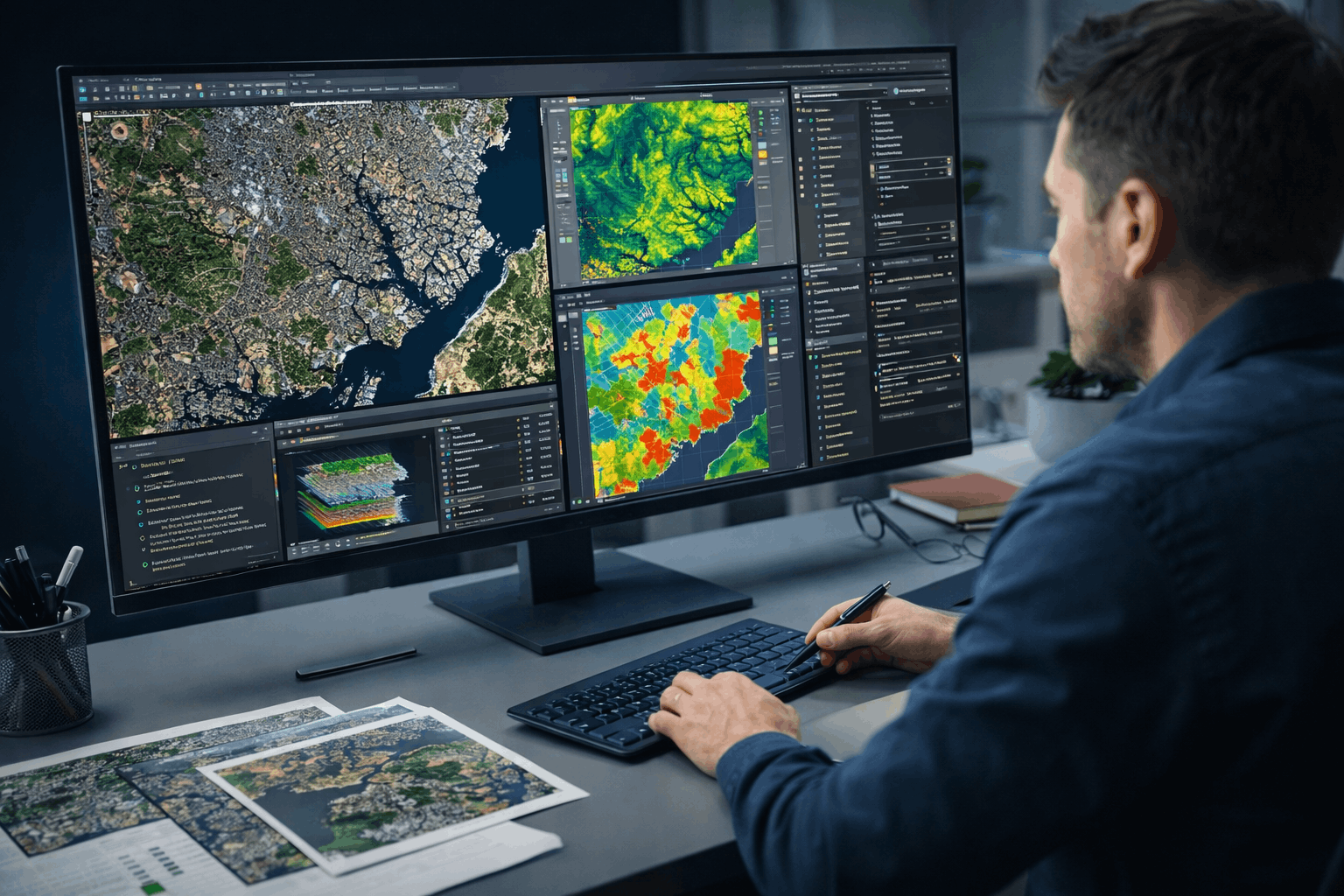
GIS Remote Sensing is an essential skill for analysing, interpreting, and managing spatial data derived from satellite imagery and raster datasets. This course is designed to provide learners with practical, job-relevant knowledge of remote sensing workflows using ArcGIS, with a strong emphasis on real-world applications rather than abstract theory.
The course begins by introducing the fundamentals of remote sensing, including satellite imagery, spectral bands, and how raster data represents real-world features. Learners then progress to hands-on techniques such as layer stacking, georeferencing satellite images, and working with toposheets to ensure spatial accuracy. These skills form the foundation for advanced spatial analysis and decision-making.
As the course develops, learners gain practical exposure to geoprocessing raster tools and raster analysis functions within ArcGIS. Key analytical workflows such as site suitability modelling using weighted overlay analysis are explored in detail, enabling learners to understand how spatial criteria are evaluated for planning and development purposes. The course also covers watershed delineation from DEM data, helping learners analyse terrain, drainage patterns, and hydrological behaviour. Unsupervised classification techniques are introduced to demonstrate how land cover patterns can be identified and interpreted from satellite imagery.
By the end of the course, learners will be able to confidently handle raster datasets, perform spatial analysis, and apply remote sensing techniques to environmental management, urban planning, and resource analysis. The skills gained are highly relevant across academic, research, and professional GIS contexts.
On successful completion, learners will receive a free course completion certificate. For those who require formal recognition, multiple premium certificate and transcript options are also available for purchase. Learners also benefit from 5-star rated support available 24/7 via email, ensuring expert guidance throughout the learning process.
Completing this course can support roles such as GIS analyst, remote sensing technician, environmental analyst, urban planning assistant, or research support officer. It also provides a strong foundation for advanced study in geospatial science, environmental modelling, or spatial data analytics.
Who is this course for?
GIS Remote Sensing is an essential skill for analysing, interpreting, and managing spatial data derived from satellite imagery and raster datasets. This course is designed to provide learners with practical, job-relevant knowledge of remote sensing workflows using ArcGIS, with a strong emphasis on real-world applications rather than abstract theory.
The course begins by introducing the fundamentals of remote sensing, including satellite imagery, spectral bands, and how raster data represents real-world features. Learners then progress to hands-on techniques such as layer stacking, georeferencing satellite images, and working with toposheets to ensure spatial accuracy. These skills form the foundation for advanced spatial analysis and decision-making.
As the course develops, learners gain practical exposure to geoprocessing raster tools and raster analysis functions within ArcGIS. Key analytical workflows such as site suitability modelling using weighted overlay analysis are explored in detail, enabling learners to understand how spatial criteria are evaluated for planning and development purposes. The course also covers watershed delineation from DEM data, helping learners analyse terrain, drainage patterns, and hydrological behaviour. Unsupervised classification techniques are introduced to demonstrate how land cover patterns can be identified and interpreted from satellite imagery.
By the end of the course, learners will be able to confidently handle raster datasets, perform spatial analysis, and apply remote sensing techniques to environmental management, urban planning, and resource analysis. The skills gained are highly relevant across academic, research, and professional GIS contexts.
On successful completion, learners will receive a free course completion certificate. For those who require formal recognition, multiple premium certificate and transcript options are also available for purchase. Learners also benefit from 5-star rated support available 24/7 via email, ensuring expert guidance throughout the learning process.
Completing this course can support roles such as GIS analyst, remote sensing technician, environmental analyst, urban planning assistant, or research support officer. It also provides a strong foundation for advanced study in geospatial science, environmental modelling, or spatial data analytics.
Requirements
GIS Remote Sensing is an essential skill for analysing, interpreting, and managing spatial data derived from satellite imagery and raster datasets. This course is designed to provide learners with practical, job-relevant knowledge of remote sensing workflows using ArcGIS, with a strong emphasis on real-world applications rather than abstract theory.
The course begins by introducing the fundamentals of remote sensing, including satellite imagery, spectral bands, and how raster data represents real-world features. Learners then progress to hands-on techniques such as layer stacking, georeferencing satellite images, and working with toposheets to ensure spatial accuracy. These skills form the foundation for advanced spatial analysis and decision-making.
As the course develops, learners gain practical exposure to geoprocessing raster tools and raster analysis functions within ArcGIS. Key analytical workflows such as site suitability modelling using weighted overlay analysis are explored in detail, enabling learners to understand how spatial criteria are evaluated for planning and development purposes. The course also covers watershed delineation from DEM data, helping learners analyse terrain, drainage patterns, and hydrological behaviour. Unsupervised classification techniques are introduced to demonstrate how land cover patterns can be identified and interpreted from satellite imagery.
By the end of the course, learners will be able to confidently handle raster datasets, perform spatial analysis, and apply remote sensing techniques to environmental management, urban planning, and resource analysis. The skills gained are highly relevant across academic, research, and professional GIS contexts.
On successful completion, learners will receive a free course completion certificate. For those who require formal recognition, multiple premium certificate and transcript options are also available for purchase. Learners also benefit from 5-star rated support available 24/7 via email, ensuring expert guidance throughout the learning process.
Completing this course can support roles such as GIS analyst, remote sensing technician, environmental analyst, urban planning assistant, or research support officer. It also provides a strong foundation for advanced study in geospatial science, environmental modelling, or spatial data analytics.
Career path
GIS Remote Sensing is an essential skill for analysing, interpreting, and managing spatial data derived from satellite imagery and raster datasets. This course is designed to provide learners with practical, job-relevant knowledge of remote sensing workflows using ArcGIS, with a strong emphasis on real-world applications rather than abstract theory.
The course begins by introducing the fundamentals of remote sensing, including satellite imagery, spectral bands, and how raster data represents real-world features. Learners then progress to hands-on techniques such as layer stacking, georeferencing satellite images, and working with toposheets to ensure spatial accuracy. These skills form the foundation for advanced spatial analysis and decision-making.
As the course develops, learners gain practical exposure to geoprocessing raster tools and raster analysis functions within ArcGIS. Key analytical workflows such as site suitability modelling using weighted overlay analysis are explored in detail, enabling learners to understand how spatial criteria are evaluated for planning and development purposes. The course also covers watershed delineation from DEM data, helping learners analyse terrain, drainage patterns, and hydrological behaviour. Unsupervised classification techniques are introduced to demonstrate how land cover patterns can be identified and interpreted from satellite imagery.
By the end of the course, learners will be able to confidently handle raster datasets, perform spatial analysis, and apply remote sensing techniques to environmental management, urban planning, and resource analysis. The skills gained are highly relevant across academic, research, and professional GIS contexts.
On successful completion, learners will receive a free course completion certificate. For those who require formal recognition, multiple premium certificate and transcript options are also available for purchase. Learners also benefit from 5-star rated support available 24/7 via email, ensuring expert guidance throughout the learning process.
Completing this course can support roles such as GIS analyst, remote sensing technician, environmental analyst, urban planning assistant, or research support officer. It also provides a strong foundation for advanced study in geospatial science, environmental modelling, or spatial data analytics.
-
- Remote sensing, satellite images, spectral band’s introduction 00:10:00
-
- Layers stacking satellite images 00:10:00
- Georeferencing satellite images 00:10:00
- Raster Analysis Functions 00:10:00
- Site suitability using weighted overlay analysis – part 1 00:10:00
- Watershed Delineation from DEM 00:10:00
- Exam of GIS Remote Sensing in ArcGIS 00:50:00

No Reviews found for this course.
Is this certificate recognized?
Yes, our premium certificate and transcript are widely recognized and accepted by embassies worldwide, particularly by the UK embassy. This adds credibility to your qualification and enhances its value for professional and academic purposes.
I am a beginner. Is this course suitable for me?
Yes, this course is designed for learners of all levels, including beginners. The content is structured to provide step-by-step guidance, ensuring that even those with no prior experience can follow along and gain valuable knowledge.
I am a professional. Is this course suitable for me?
Yes, professionals will also benefit from this course. It covers advanced concepts, practical applications, and industry insights that can help enhance existing skills and knowledge. Whether you are looking to refine your expertise or expand your qualifications, this course provides valuable learning.
Does this course have an expiry date?
No, you have lifetime access to the course. Once enrolled, you can revisit the materials at any time as long as the course remains available. Additionally, we regularly update our content to ensure it stays relevant and up to date.
How do I claim my free certificate?
I trust you’re in good health. Your free certificate can be located in the Achievement section. The option to purchase a CPD certificate is available but entirely optional, and you may choose to skip it. Please be aware that it’s crucial to click the “Complete” button to ensure the certificate is generated, as this process is entirely automated.
Does this course have assessments and assignments?
Yes, the course includes both assessments and assignments. Your final marks will be determined by a combination of 20% from assignments and 80% from assessments. These evaluations are designed to test your understanding and ensure you have grasped the key concepts effectively.
Is this course accredited?
We are a recognized course provider with CPD, UKRLP, and AOHT membership. The logos of these accreditation bodies will be featured on your premium certificate and transcript, ensuring credibility and professional recognition.
Will I receive a certificate upon completion?
Yes, you will receive a free digital certificate automatically once you complete the course. If you would like a premium CPD-accredited certificate, either in digital or physical format, you can upgrade for a small fee.
Course Features
Price
Study Method
Online | Self-paced
Course Format
Reading Material - PDF, article
Duration
2 hours, 45 minutes
Qualification
No formal qualification
Certificate
At completion
Additional info
Coming soon
- Share

Goalkeeper Positioning Level 4: Angles, Distances & Tactical Awareness
Course Line237ر.س2,472.34Original price was: ر.س2,472.34.ر.س75.63Current price is: ر.س75.63.Acoustic Design for Buildings and Spaces Level 3 Advanced Diploma
Course Line240ر.س2,472.34Original price was: ر.س2,472.34.ر.س75.63Current price is: ر.س75.63.Mental Health Nursing Level 5 Advanced Diploma
Course Line249ر.س2,472.34Original price was: ر.س2,472.34.ر.س75.63Current price is: ر.س75.63.


Related Courses
Microsoft Excel for Business: Beginner to Advanced Data Analysis
ر.س2,472.34Original price was: ر.س2,472.34.ر.س75.63Current price is: ر.س75.63.237AutoCAD Floor Plan Rendering in Photoshop: Architectural Visualisation Professional Training
ر.س2,472.34Original price was: ر.س2,472.34.ر.س75.63Current price is: ر.س75.63.237C++ Programming for Beginners: From Zero to AI-Ready Developer
ر.س2,472.34Original price was: ر.س2,472.34.ر.س75.63Current price is: ر.س75.63.237