Course Features
Price
Study Method
Online | Self-paced
Course Format
Reading Material - PDF, article
Duration
6 hours, 25 minutes
Qualification
No formal qualification
Certificate
At completion
Additional info
Coming soon
- Share
Overview
The Remote Sensing Image Processing Level 3 Advanced Diploma offers an in-depth exploration of remote sensing technology, data interpretation, and digital image processing techniques. As global industries increasingly rely on satellite imagery, aerial data, and UAV-generated visuals to make informed decisions, this course provides learners with the technical knowledge and practical capabilities to analyse, classify, and apply remote sensing data in real-world scenarios.
The course begins with an introduction to remote sensing, providing historical context and examining various platforms such as satellites, aircraft, and drones. Learners will understand the basic principles of image acquisition and explore the evolution of remote sensing technologies that have transformed environmental monitoring, land-use planning, disaster management, and other critical fields.
The fundamentals of image processing are then introduced, covering essential techniques like enhancement, restoration, transformation, and registration. These foundational skills allow learners to improve image quality, align multiple data sources, and prepare imagery for advanced analysis. Learners will gain a strong grasp of how digital processing methods enhance the value and accuracy of raw remote sensing data.
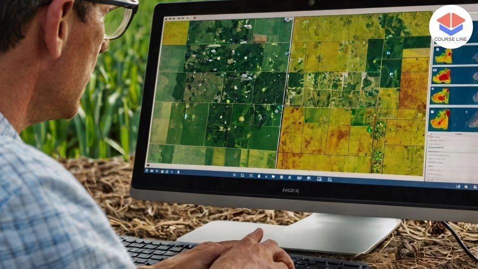
A dedicated module on remote sensing data sources delves into the capabilities of satellite imagery, aerial photography, hyperspectral sensors, LiDAR, and UAV-based platforms. This comprehensive approach equips learners with the versatility to work with different types of data depending on the application area.
Image classification and analysis are core to this course. Students will learn the theory and practice of supervised and unsupervised classification, perform accuracy assessments, and carry out change detection analysis to identify temporal shifts in land use or environmental conditions. Time-series analysis adds another layer of complexity and relevance for those working in climate studies or natural resource monitoring.
In the advanced techniques section, learners explore Object-Based Image Analysis (OBIA), machine learning applications, and the integration of remote sensing data with Geographic Information Systems (GIS). These forward-thinking modules prepare students to apply cutting-edge technologies in domains like precision agriculture, urban expansion modelling, and ecosystem analysis.
The course also features practical applications in various sectors, including land use mapping, regional development planning, forestry management, agricultural assessment, and emergency response coordination. A project management module walks learners through planning, proposal writing, data acquisition, workflow organisation, and final report preparation, ensuring readiness for both academic and professional assignments.
Finally, students explore the future of remote sensing, emerging technologies, and its growing role in addressing global challenges such as climate change. The course also introduces ethical and legal considerations to promote responsible data use and compliance with global data protection standards.
By the end of this diploma, learners will have gained the knowledge and technical proficiency needed to manage and analyse remote sensing imagery, making them valuable assets in the geospatial, environmental, and planning sectors.
Graduates of the Remote Sensing Image Processing Level 3 Advanced Diploma can pursue careers as remote sensing analysts, GIS technicians, environmental consultants, geospatial data specialists, UAV data analysts, or urban planning assistants. The course also lays the groundwork for further study or specialised certification in geoinformatics, environmental monitoring, or Earth observation technologies.
Who is this course for?
The Remote Sensing Image Processing Level 3 Advanced Diploma offers an in-depth exploration of remote sensing technology, data interpretation, and digital image processing techniques. As global industries increasingly rely on satellite imagery, aerial data, and UAV-generated visuals to make informed decisions, this course provides learners with the technical knowledge and practical capabilities to analyse, classify, and apply remote sensing data in real-world scenarios.
The course begins with an introduction to remote sensing, providing historical context and examining various platforms such as satellites, aircraft, and drones. Learners will understand the basic principles of image acquisition and explore the evolution of remote sensing technologies that have transformed environmental monitoring, land-use planning, disaster management, and other critical fields.
The fundamentals of image processing are then introduced, covering essential techniques like enhancement, restoration, transformation, and registration. These foundational skills allow learners to improve image quality, align multiple data sources, and prepare imagery for advanced analysis. Learners will gain a strong grasp of how digital processing methods enhance the value and accuracy of raw remote sensing data.
A dedicated module on remote sensing data sources delves into the capabilities of satellite imagery, aerial photography, hyperspectral sensors, LiDAR, and UAV-based platforms. This comprehensive approach equips learners with the versatility to work with different types of data depending on the application area.
Image classification and analysis are core to this course. Students will learn the theory and practice of supervised and unsupervised classification, perform accuracy assessments, and carry out change detection analysis to identify temporal shifts in land use or environmental conditions. Time-series analysis adds another layer of complexity and relevance for those working in climate studies or natural resource monitoring.
In the advanced techniques section, learners explore Object-Based Image Analysis (OBIA), machine learning applications, and the integration of remote sensing data with Geographic Information Systems (GIS). These forward-thinking modules prepare students to apply cutting-edge technologies in domains like precision agriculture, urban expansion modelling, and ecosystem analysis.
The course also features practical applications in various sectors, including land use mapping, regional development planning, forestry management, agricultural assessment, and emergency response coordination. A project management module walks learners through planning, proposal writing, data acquisition, workflow organisation, and final report preparation, ensuring readiness for both academic and professional assignments.
Finally, students explore the future of remote sensing, emerging technologies, and its growing role in addressing global challenges such as climate change. The course also introduces ethical and legal considerations to promote responsible data use and compliance with global data protection standards.
By the end of this diploma, learners will have gained the knowledge and technical proficiency needed to manage and analyse remote sensing imagery, making them valuable assets in the geospatial, environmental, and planning sectors.
Graduates of the Remote Sensing Image Processing Level 3 Advanced Diploma can pursue careers as remote sensing analysts, GIS technicians, environmental consultants, geospatial data specialists, UAV data analysts, or urban planning assistants. The course also lays the groundwork for further study or specialised certification in geoinformatics, environmental monitoring, or Earth observation technologies.
Requirements
The Remote Sensing Image Processing Level 3 Advanced Diploma offers an in-depth exploration of remote sensing technology, data interpretation, and digital image processing techniques. As global industries increasingly rely on satellite imagery, aerial data, and UAV-generated visuals to make informed decisions, this course provides learners with the technical knowledge and practical capabilities to analyse, classify, and apply remote sensing data in real-world scenarios.
The course begins with an introduction to remote sensing, providing historical context and examining various platforms such as satellites, aircraft, and drones. Learners will understand the basic principles of image acquisition and explore the evolution of remote sensing technologies that have transformed environmental monitoring, land-use planning, disaster management, and other critical fields.
The fundamentals of image processing are then introduced, covering essential techniques like enhancement, restoration, transformation, and registration. These foundational skills allow learners to improve image quality, align multiple data sources, and prepare imagery for advanced analysis. Learners will gain a strong grasp of how digital processing methods enhance the value and accuracy of raw remote sensing data.
A dedicated module on remote sensing data sources delves into the capabilities of satellite imagery, aerial photography, hyperspectral sensors, LiDAR, and UAV-based platforms. This comprehensive approach equips learners with the versatility to work with different types of data depending on the application area.
Image classification and analysis are core to this course. Students will learn the theory and practice of supervised and unsupervised classification, perform accuracy assessments, and carry out change detection analysis to identify temporal shifts in land use or environmental conditions. Time-series analysis adds another layer of complexity and relevance for those working in climate studies or natural resource monitoring.
In the advanced techniques section, learners explore Object-Based Image Analysis (OBIA), machine learning applications, and the integration of remote sensing data with Geographic Information Systems (GIS). These forward-thinking modules prepare students to apply cutting-edge technologies in domains like precision agriculture, urban expansion modelling, and ecosystem analysis.
The course also features practical applications in various sectors, including land use mapping, regional development planning, forestry management, agricultural assessment, and emergency response coordination. A project management module walks learners through planning, proposal writing, data acquisition, workflow organisation, and final report preparation, ensuring readiness for both academic and professional assignments.
Finally, students explore the future of remote sensing, emerging technologies, and its growing role in addressing global challenges such as climate change. The course also introduces ethical and legal considerations to promote responsible data use and compliance with global data protection standards.
By the end of this diploma, learners will have gained the knowledge and technical proficiency needed to manage and analyse remote sensing imagery, making them valuable assets in the geospatial, environmental, and planning sectors.
Graduates of the Remote Sensing Image Processing Level 3 Advanced Diploma can pursue careers as remote sensing analysts, GIS technicians, environmental consultants, geospatial data specialists, UAV data analysts, or urban planning assistants. The course also lays the groundwork for further study or specialised certification in geoinformatics, environmental monitoring, or Earth observation technologies.
Career path
The Remote Sensing Image Processing Level 3 Advanced Diploma offers an in-depth exploration of remote sensing technology, data interpretation, and digital image processing techniques. As global industries increasingly rely on satellite imagery, aerial data, and UAV-generated visuals to make informed decisions, this course provides learners with the technical knowledge and practical capabilities to analyse, classify, and apply remote sensing data in real-world scenarios.
The course begins with an introduction to remote sensing, providing historical context and examining various platforms such as satellites, aircraft, and drones. Learners will understand the basic principles of image acquisition and explore the evolution of remote sensing technologies that have transformed environmental monitoring, land-use planning, disaster management, and other critical fields.
The fundamentals of image processing are then introduced, covering essential techniques like enhancement, restoration, transformation, and registration. These foundational skills allow learners to improve image quality, align multiple data sources, and prepare imagery for advanced analysis. Learners will gain a strong grasp of how digital processing methods enhance the value and accuracy of raw remote sensing data.
A dedicated module on remote sensing data sources delves into the capabilities of satellite imagery, aerial photography, hyperspectral sensors, LiDAR, and UAV-based platforms. This comprehensive approach equips learners with the versatility to work with different types of data depending on the application area.
Image classification and analysis are core to this course. Students will learn the theory and practice of supervised and unsupervised classification, perform accuracy assessments, and carry out change detection analysis to identify temporal shifts in land use or environmental conditions. Time-series analysis adds another layer of complexity and relevance for those working in climate studies or natural resource monitoring.
In the advanced techniques section, learners explore Object-Based Image Analysis (OBIA), machine learning applications, and the integration of remote sensing data with Geographic Information Systems (GIS). These forward-thinking modules prepare students to apply cutting-edge technologies in domains like precision agriculture, urban expansion modelling, and ecosystem analysis.
The course also features practical applications in various sectors, including land use mapping, regional development planning, forestry management, agricultural assessment, and emergency response coordination. A project management module walks learners through planning, proposal writing, data acquisition, workflow organisation, and final report preparation, ensuring readiness for both academic and professional assignments.
Finally, students explore the future of remote sensing, emerging technologies, and its growing role in addressing global challenges such as climate change. The course also introduces ethical and legal considerations to promote responsible data use and compliance with global data protection standards.
By the end of this diploma, learners will have gained the knowledge and technical proficiency needed to manage and analyse remote sensing imagery, making them valuable assets in the geospatial, environmental, and planning sectors.
Graduates of the Remote Sensing Image Processing Level 3 Advanced Diploma can pursue careers as remote sensing analysts, GIS technicians, environmental consultants, geospatial data specialists, UAV data analysts, or urban planning assistants. The course also lays the groundwork for further study or specialised certification in geoinformatics, environmental monitoring, or Earth observation technologies.
-
- Overview of Remote Sensing 00:10:00
- History and Evolution 00:10:00
- Types of Remote Sensing Platforms 00:10:00
- Basics of Image Acquisition 00:10:00
-
- Introduction to Image Processing 00:10:00
- Image Enhancement Techniques 00:10:00
- Image Restoration Methods 00:10:00
- Image Transformation and Registration 00:10:00
- Satellite Remote Sensing 00:10:00
- Aerial Photography 00:10:00
- Unmanned Aerial Vehicles (UAVs) 00:10:00
- Hyperspectral and LiDAR Data 00:10:00
- Object-Based Image Analysis (OBIA) 00:10:00
- Machine Learning in Remote Sensing 00:10:00
- Integration of Remote Sensing with Geographic Information Systems (GIS) 00:10:00
- Advanced Applications in Environmental Monitoring and Natural Resource 00:10:00
- Project Planning and Proposal Writing 00:10:00
- Data Acquisition and Preprocessing 00:10:00
- Image Processing Workflow 00:10:00
- Report Writing and Presentation Skills 00:10:00
- Exam of Remote Sensing Image Processing Level 3 Advanced Diploma 00:50:00

No Reviews found for this course.
Is this certificate recognized?
Yes, our premium certificate and transcript are widely recognized and accepted by embassies worldwide, particularly by the UK embassy. This adds credibility to your qualification and enhances its value for professional and academic purposes.
I am a beginner. Is this course suitable for me?
Yes, this course is designed for learners of all levels, including beginners. The content is structured to provide step-by-step guidance, ensuring that even those with no prior experience can follow along and gain valuable knowledge.
I am a professional. Is this course suitable for me?
Yes, professionals will also benefit from this course. It covers advanced concepts, practical applications, and industry insights that can help enhance existing skills and knowledge. Whether you are looking to refine your expertise or expand your qualifications, this course provides valuable learning.
Does this course have an expiry date?
No, you have lifetime access to the course. Once enrolled, you can revisit the materials at any time as long as the course remains available. Additionally, we regularly update our content to ensure it stays relevant and up to date.
How do I claim my free certificate?
I trust you’re in good health. Your free certificate can be located in the Achievement section. The option to purchase a CPD certificate is available but entirely optional, and you may choose to skip it. Please be aware that it’s crucial to click the “Complete” button to ensure the certificate is generated, as this process is entirely automated.
Does this course have assessments and assignments?
Yes, the course includes both assessments and assignments. Your final marks will be determined by a combination of 20% from assignments and 80% from assessments. These evaluations are designed to test your understanding and ensure you have grasped the key concepts effectively.
Is this course accredited?
We are a recognized course provider with CPD, UKRLP, and AOHT membership. The logos of these accreditation bodies will be featured on your premium certificate and transcript, ensuring credibility and professional recognition.
Will I receive a certificate upon completion?
Yes, you will receive a free digital certificate automatically once you complete the course. If you would like a premium CPD-accredited certificate, either in digital or physical format, you can upgrade for a small fee.
Course Features
Price
Study Method
Online | Self-paced
Course Format
Reading Material - PDF, article
Duration
6 hours, 25 minutes
Qualification
No formal qualification
Certificate
At completion
Additional info
Coming soon
- Share

ESOL Speaking Practice: Role-Plays & Real-Life Scenarios
Course Line237£490.00Original price was: £490.00.£14.99Current price is: £14.99.Healthcare Management Level 3 Advanced Diploma
Course Line237£490.00Original price was: £490.00.£14.99Current price is: £14.99.Elite Football Scouting Level 7: Player Profiling & Advanced Recruitment Strategy
Course Line237£490.00Original price was: £490.00.£14.99Current price is: £14.99.